Maintaining safe airspace

Maintaining safe shared airspace is an important priority for all glider pilots. The following guidance aims to support pilots with maintaining safe airspace for all.
Lookout – supported by use of radio & electronic conspicuity
Lookout is the primary method of collision avoidance in class G airspace. It’s important to recognise that effective lookout requires technique supported by other attributes available to pilots including technology.
Read more about lookout supported by technology here
Airfields
- Most collisions occur close to airfields. Being on the correct frequency well before getting close to an ATZ or in the local vicinity of an airfield will enable a pilot to build a mental picture of what is going on, including in-use runways and traffic levels.
- Talking to a controller when other traffic may be flying procedurally into the airfield is very likely to be helpful and contribute to safe airspace. Read more under Instrument Approach Procedures below.
- Learn before flight how to find airfield information using your paper or electronic chart.
- Just because you are landing at an airfield without ATC or A/G, don’t be stealthy. How do you know there’s no-one else around? You can help other pilots with their situational awareness by making blind radio calls in the circuit, e.g. left/right downwind, base, and final approach to whatever runway is in use.
Airprox
- When a pilot feels that the proximity of another aircraft was in their view unsafe, they can submit an Airprox report.
- Airprox reports are investigated and given a risk category.
- You can learn more on the Airprox website, which includes their published Airprox investigation reports.
Altimetry
- An altimeter is a device used to measure the vertical distance between the instrument and a datum pressure level. The datum pressure level can be adjusted by the pilot.
- It is really important that pilots understand which setting is required to obtain the correct information that relates to the airspace.
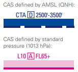
This altimetry tutorial is a useful refresher for any glider pilot.
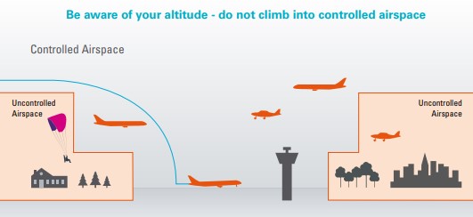
Avoiding infringements
- Infringements, ie entering controlled, danger, restricted or prohibited airspace without the authority to do so, are potentially dangerous and disruptive, and ultimately result in the curtailment of the freedoms to fly that all pilots need and enjoy.
- The BGA strongly recommends careful pre-flight planning and use of a GPS moving map with current airspace files and the device’s attention seeking vertical and horizontal warnings set to provide ample time to react and avoid controlled airspace.
- The CAA notes ‘that as part of Threat and Error Management, pilots are recommended to maintain adequate separation from notified airspace through the application of the ‘Take 2’ guidance, i.e maintain 200′ vertical separation and 2nm horizontal separation from controlled airspace. The suggested 200 feet distance may need to be increased where strong thermal or wave conditions are encountered to prevent inadvertent climbs into controlled airspace’.
Charts and GPS moving maps
- Glider pilots use the 1:500 000 chart that is designed for use in visual navigation. The charts are regularly updated. Out of date charts should be discarded. VFR chart information, including a list of stockists, is available on the NATS AIS website. Radio frequency cards are available on the NATS website. A gliding frequency reference card has been produced by Paul Ruskin, and is available as part of the Airfields and Outlandings distribution available here.
- GPS moving maps are pilot-friendly. Global Position Satellite navigation is used extensively in aviation. In many parts of the UK’s complicated airspace structure, it does not make sense to fly without a GPS moving map. Most glider pilots use a GPS moving map even when soaring locally. A number of GPS moving map options are available, all of which take much of the horizontal and vertical navigation load that otherwise would distract from flying the glider and looking out.
- Controlled airspace changes every now and again. The 1/2 million hard copy chart is updated annually. It’s very important that GPS data files are also updated. Pilots should note that they should must understand the settings work on their GPS moving map, take great care when programming it before flight, and must always maintain situational awareness in flight through using visual navigation techniques and a current chart; this final point is nothing to do with ‘old school’ – it’s simply an important aspect of threat and error management, ie cross checking and being prepared for equipment failure or pilot ‘finger trouble’.
View BGA information on airspace and turning point files here.
D&D – getting help
The military Distress and Diversion Cell is manned 24 hours to provide an emergency and fixer (location) service on 121.5 for all military and civil aircraft. Read more here.
Instrument Approach Procedures
A number of airfields in the UK have instrument traffic procedures which are detailed in the UK AIP but not shown on 1/2 mil charts. In some cases the instrument approaches are indicated by a feather on the ½ mil chart (for example Cambridge, Cranfield, Exeter, Gloucester, Inverness, Londonderry, Oxford and most military airfields. These feathers can be indicated on most GPS moving map software.
Invariably, instrument traffic operating in Class G is not looking out as effectively as most would expect.
Here is an example of an instrument approach procedure that is not marked on the 1/2 mil charts used by most pilots:
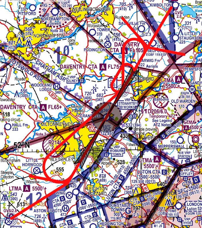
When operating close to these airfields, pilots should listen out on the ATC frequency. Where there is a need to operate overhead the airfield, or when vertically close to and when horizontally within say an approximate 20 degree arc either side of the instrument approach ‘slope’, it can be very helpful if the glider pilot makes contact with ATC prefixing the call with ‘glider’, stating their location (eg 5nm NE of the airfield at 2000’) and stating their intentions (eg to climb, to glide to xxxxx, etc). Please don’t forget that last minute calls can result in pilot overload as the pressure comes on. Most air traffic controllers have little appreciation of pilot workload but will help where they can. As ever, aviate, navigate and communicate in that order.
Specific guidance
Helpful guidance from Cambridge GC
Cranfield airfield safe shared airspace self-briefing.
Lakenheath & Mildenhall safe shared airspace self-briefing
Oxford airport safe shared airspace self-briefing
LOA’s
- Where there is a need and the related risks can be managed appropriately, it is possible to establish letters of agreement between airspace controlling authorities and operators. Sometimes these are national arrangements. In other cases these are local arrangements. Some LoA’s are legally binding. Others are voluntary in nature. In all cases, pilots must understand and comply FULLY with the detail within the LoA. If in doubt, ask. Do not assume.
- Some clubs have a local agreement with NATS on flexible use of airspace. The ongoing success of the agreement between London GC and NATS is reliant on pilots receiving a specific, face to face briefing by the London GC. Unless that LoA briefing has taken place and pilots are briefed on the operating protocols in place on the day, pilots may not use the LoA. The LoA is not published on this website. Contact the London GC for further details.
- Letters of Agreement are restricted private and cannot be published. Clubs should hold a copy where relevant (the BGA can supply a copy). If a pilot or club identifies any changes or errors with LoA’s, please contact the Airspace Committee via the BGA office.
- Please note that at the end of 2025, the CAA published a new policy describing a requirement to review certain LoAs and where required develop permanent airspace changes. See CAP3096.
NOTAMs
- All pilots are expected to check NOTAMs (Notices to Aviation) before flight. Learning how to access NOTAMs forms a part of glider pilot training. The official NATS/CAA supplied method of obtaining NOTAMs is not fit for purpose. There are several excellent software tools available that help pilots easily obtain and interpret NOTAM information, including Skydemon, which uses source data and graphically embeds NOTAMs into the main map, leading to greatly enhanced awareness of how a temporary notified situation could affect a potential flight.
- There is a phone number available for checking a pre-recorded message re changes in airspace status – 0500 354802.
- There’s useful guidance on Paul Ruskin’s Gliding Matters webpages here.
Notification of gliding activity
Permanent or temporary changes in gliding activity are notified to the CAA to ensure that other airspace users are aware. Read more on this CAA webpage.
Task activity, where notified on Soaring Spot by the task planners/competition organisers, is automatically displayed on a Gliding Tasks Today webpage to inform other airspace users.
Parachute Drop Zones
- Skydiving takes place into Drop Zones (DZs), radius 1.5 or 2nm up to FL150, as marked on a chart and listed in the UK AIP.
- Please note that skydivers usually drop directly upwind of the DZ and routinely descend through cloud.
- The ANO 240 notes that ‘a person must not recklessly or negligently act in a manner likely to endanger an aircraft, or any person in an aircraft’. The ANO 241 notes ‘that a person must not recklessly or negligently cause or permit an aircraft to endanger any person or property’.
- When in-flight, the local ATC unit should be able to say if the site is likely to be active. By talking directly to the DZ, a pilot may decide that it is safe to cross. In the event of receiving a nil response from the DZ frequency, the glider pilot should act on the information given by the ATC unit and, if in any doubt, remain clear of the DZ. Be aware that drop-planes operate outside as well as inside a DZ to position themselves for the drop. They often manoeuvre sharply with steep descents. The major sites at Langar, Peterborough Sibson, and Hinton-in-the Hedges are very busy. The Weston on the Green military DZ is located within a Danger Area (D129). Temporary DZ sites (notified by NOTAM) can be particularly difficult to identify.
- A pilot may see other flying activity within a DZ. Local flying activity within a DZ is subject to local safety protocols – do not assume that any aircraft can fly within an active DZ.
- A pilot will not see a free-falling parachutist in time to avoid a collision. If in doubt, stay out.
- Current parachute DZ information can be found in the UK AIP under ENR 5.5.
- British Skydiving publishes this online map.
There is a pilot self-briefing ‘Safe Shared Airspace – Avoiding Active DZs’ here.
Parachuting NOTAMs
With all parachute dropping NOTAMs, there is no change to airspace classification from Class G or Special Use Area notified for the activity. If there is any overlap of the notified area and airspace of a higher classification, then the sponsor is responsible for obtaining clearance to enter that airspace from the relevant controlling authority. Some parachuting NOTAMs support specialist activity that can take place in an ‘inverted cone’ above the landing area. The ‘conical’ (upside-down tiered wedding cake) normally starts with the 3nm radius and 3000ft cylinder and expands by 3nm every 3000ft until the higher levels, as shown in the highlighted area of the NOTAM below:
PJE WI 20NM RADIUS OF 515130N 0014208W (LITTLE RISSINGTON). DROP
CONTAINED WI FLW CONE (ALL HGT AMSL): SFC-3000FT 3NM RADIUS,
3001FT-6000FT 6NM RADIUS, 6001FT-9000FT 9NM RADIUS,
9001FT-13000FT 12NM RADIUS, 13001FT-18000FT 15NM RADIUS,
18001FT-22000FT 20NM RADIUS. DROP HGT SUBJ ATC CLR. FOR INFO
01993 895052. AR-2026-3113/07.
The wider area at the top of the cone allows jumps to be made offset from the DZ, which accommodates tactical requirements and accounts for weather. The NOTAM’d area accounts for drops that do not commence from the middle of the area and go straight down, which may not be practicable from such an altitude.
The contact number on the NOTAM should be monitored by an appropriate representative of the organisation who can provide information on activity and planned drop timings. There is no mandatory avoid as such associated with the area as long as there is no endangerment to the parachutists or the aircraft undertaking the drops, and compliance with the rules of the air is maintained.
Task setting
Airspace is a fundamental consideration when task setting. Learn more about task setting here.
Winch launch overflights
- Overflights of winch launches by aircraft are potentially hazardous.
- Pilots should report any overflight of a winch launch that they believe had the potential to endanger a glider during a winch launch. The BGA uses the information to educate others.
How to report a winch launch overflight is describe here.
Engaging with others
There are two regionally based entities that aim to provide local stakeholder awareness and engagement. The BGA recommends that gliding clubs get involved where they can.
Regional Airspace User Working Groups (RAUWGs)
- RAUWGs are a Royal Air Force initiative designed to encourage cooperation and the sharing of good practice between those who operate or control within the same airspace areas. If you are involved in flying, gliding, parachuting, model aircraft flying or the controlling of air systems, please contact your closest group and get involved.
- The main aim of each RAUWG is to act as a collaborative forum which seeks to reduce the risk of mid-air collision. RAUWGs give shared airspace users, both military and civilian, the opportunity to liaise with each other in a relaxed and informal environment. Meetings are held across the country on a 6 monthly basis and they normally take place at a Royal Air Force station that is the most central or the most appropriate for the region.
Local Airspace Infringement Teams (LAITs)
LAITs have been set up to cover infringement hot-spots.
- Bristol serving Bristol CTR/CTA
- Channel Islands serving Channel Islands CTR/CTA and TMA
- Gatwick serving Gatwick CTR/CTA
- London serving London CTR/London City CTR/CTA
- Luton serving Luton CTR/CTA
- Midlands serving Birmingham CTR/CTA and East Midlands CTR/CTA
- North West serving Manchester and Liverpool CTR/CTA, Hawarden RMZ and Barton ATZ
- Northern Ireland serving Belfast Aldergrove CTR, Belfast City CTR, Belfast CTA and TMA and Strangford CTA
- Oxfordshire serving Brize Norton CTR and Oxford ATZ
- Scotland (Central) serving Glasgow, Edinburgh and Prestwick CTR/CTA
- Southend serving Southend CTR/CTA
- Stansted serving Stansted CTR/CTA
- Wessex serving Southampton CTR/Solent CTA, Bournemouth CTR/CTA and Farnborough CTR/CTA
- Yorkshire & Humberside serving Leeds Bradford CTR/CTA and Humberside ATZ
Each LAIT is focused on reducing of airspace infringements through local initiatives and targeted actions. This work is shared for UK-wide infringement reduction and reported to the CAA’s Airspace Infringement Challenge Group.